Current Status
Preparing for public release of version 1.0.
The GREN Mapping team is seeking contributors. Please get in touch.
Previous
Project and implementation requirements (stories, prioritization) gathered and approved.
Interchange format & implicit data model "GRENML" draft approved; under revision.
Prototype GRENML Python support library drafted, not yet released publicly.
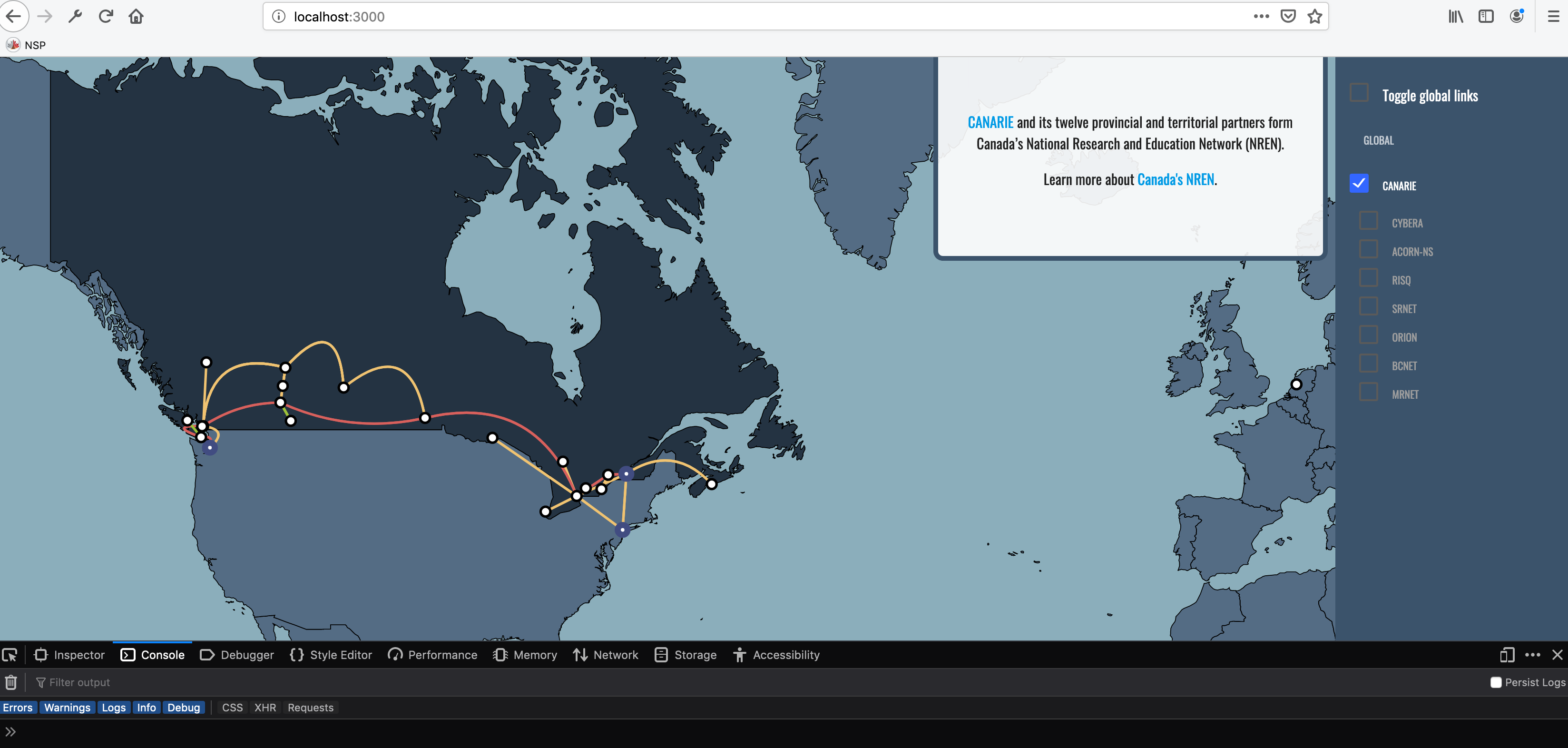
Prototype map visualisation, based on the GÉANT Map, prepared and presented at TNC19 to general interest.
Distributed database implementation plan proposed and approved.
Request for participation published and distributed.
Development under way, led by CANARIE, with assistance from RNP.
GRENML Python input/output library released, installable via PIP.
Alpha versions of standalone distributed database nodes and map visualisation display have been demoed worldwide.
Progress Log
(Meetings are held approximately bi-weekly, in English.)
Status:
A meeting is planned to be had but it has not been scheduled yet
The meeting has been scheduled but has not taken place yet
The scheduled meetings as cancelled, postponed or rescheduled
The meeting took place
| Date | Description | Status | Meeting Notes |
|---|---|---|---|
| via Zoom | Meeting Notes | |
| Special User Stories Review via Zoom | Meeting Notes | |
| via Zoom | Meeting Notes | |
| via Zoom | ||
| via Zoom | Meeting Notes | |
| Project introduction and progress presented informally at TNC19 | ||
| Update to GNA-G; this WG now reporting as GNA-G WG | ||
| via Zoom | ||
| Mid-summer checkpoint meetings | ||
| Mid-summer checkpoint meetings | ||
| Meeting signalling resumption of activities | ||
| Presentation of CANARIE's implementation design proposal | ||
| Rescheduled due to technical problems | ||
| Second presentation of implementation design proposal, fielding questions | ||
| Design proposal implicitly accepted by lack of objections | ||
| Touchpoint meeting | ||
| Ryan Davies met with John Macauley to review GRENML draft specification; some course correction is suggested
| ||
| Touchpoint meeting | ||
| Initial chat with GÉANT regarding potential development participation | ||
| Update to GNA-G | ||
| Meeting; connection details circulated via e-mail | ||
| via Zoom | Meeting Notes | |
| via Zoom | Meeting Notes | |
| vai Zoom | ||
| via Zoom | Meeting Notes | |
| via Zoom | Meeting Notes | |
| via Zoom | Meeting Notes | |
| via Zoom | Meeting Notes | |
| via Zoom | Meeting Notes | |
| via Zoom | ||
| via Zoom | Meeting Notes | |
| vai Zoom | ||
| via Zoom |
Resources
- Released Documents and Presentations
- WG Meetings and Notes
- Background documents
Existing Maps
This is not an exhaustive list. It is recognised that most networks have a static or dynamic map. We have identified the following examples as a cross-section in order to gather initial requirements for our efforts:
- GÉANT Interactive map:
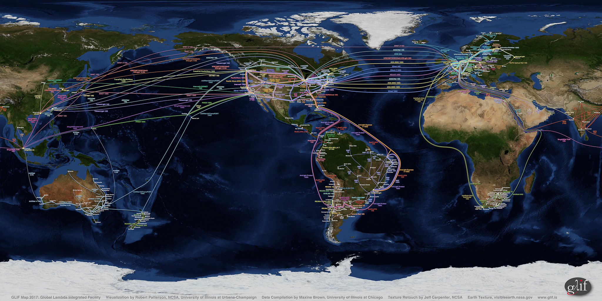
http://map.geant.org/ - GLIF map (static, artist-rendered):
https://www.glif.is/publications/maps/GLIF2017_World_2k_9-21.jpg - Global Research Map:
https://globalresearchmap.org/ - GNA Phase I compliancy map (static, artist-rendered):
https://gna-re.net/wp-content/uploads/2017/06/GNA-CI-GXPs-and-links-29-May-2017.jpg - TeleGeography map:
https://www.submarinecablemap.com/ - NetSage:
https://portal.netsage.global/ - TeleGeography
https://global-internet-map-2021.telegeography.com/